Social cohesion
Help from space
Remote sensing and geoinformation systems (GIS) offer many new possibilities to support crisis management and prevention. But what are the limitations of this methodology? Insight is provided in an interview with two disaster experts who have completely different scientific expertise: the natural scientist Dr Michael Judex, Division Head at the Federal Office of Civil Protection and Disaster Assistance (Bundesamt für Bevölkerungsschutz und Katastrophenhilfe - BBK) and the social scientist Prof. Dr Martin Voss, Head of the Disaster Research Unit at the Freie Universität (FU) Berlin.
About Mr Judex
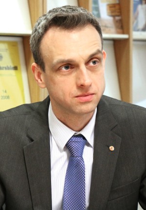
Dr Michael Judex is Division Head at the Federal Office of Civil Protection and Disaster Assistance (Bundesamt für Bevölkerungsschutz und Katastrophenhilfe - BBK), responsible for coordinating the Emergency Management Service (EMS) in the Copernicus European earth observation programme.
Learn moreFinancial Cooperation Evaluation Unit: Crises, catastrophes and conflicts – everyone is talking about these issues nowadays. They also make development cooperation increasingly challenging. You are both experts in this area even though you work in different disciplines. Is your advice more sought after than ever before?
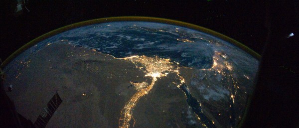
Michael Judex: Even though the BBK is a government agency with a purely national mandate, foreign countries still play a very important role for us. German aid organisations have to be supported and coordinated around the world. We do this in cooperation with the European Emergency Response Coordination Centre. We are also getting more and more enquiries from foreign organisations, particularly having to do with skill transfer and capacity building. We are currently working in this area, for example, with Jordan and Ukraine, on civil protection and CBRN risks – this stands for chemical (C), biological (B) radiological (R) and nuclear (N) risk. We have clearly seen a significant increase in the demand for the application of remote sensing, e.g. by Welthungerhilfe or the Gesellschaft für Internationale Zusammenarbeit (GIZ). A wide range of issues can be addressed with the help of remote sensing. For example, satellite images can be used to analyse the impacts of droughts on agricultural production so if food insecurity is imminent, it can be detected at an early stage. We also receive enquiries about forest or savannah fires, land degradation or deforestation, in other words, areas that are also of interest for Financial Cooperation (FC). In view of this situation, the BBK is building capacity in remote sensing to be able to provide more effective support in acute emergencies. We increasingly find that the fields where remote sensing can be used as well as its added value are far bigger than originally thought – to prevent and avoid crises, but also in the follow-up and reconstruction phase.
About Mr Voss
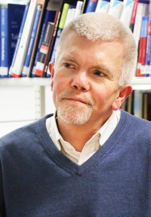
Prof. Dr Martin Voss is University professor for social disaster research at the Freie Universität Berlin, head of the Disaster Research Unit there (Katastrophenforschungsstelle - KFS).
Learn moreMartin Voss: Demand has also increased considerably in sociological disaster research. We have a lot to do! This also benefits from the security research programme of the Federal Ministry of Education and Research (Bundesministerium für Bildung und Forschung - BMBF). As a result, Germany's research landscape is virtually unparalleled. First and foremost, with the new civil protection concept of the German Federal Government and the White Paper on Civil Defence, we suddenly have a platform: there is demand for what we have developed over nearly the last two decades. In this area, our strategy of developing new services before there is acute demand for them has proved successful. Despite the currently high level of demand, there is one aspect that I don't quite like: the type of questions we are being asked. In our research, we use a very broad defnition of crises and disasters. But most stakeholders are still looking at completely changing scenarios through the same narrowly focused glasses. Which is why we still get requests for partial solutions. I think we need a completely different approach that can take an integrated view of linked processes. We see that our environment is changing. We are slowly incorporating societal factors that we didn't use to consider truly relevant to disasters into our thought process: social inequality, voluntary and involuntary migration, fluctuations in financial markets, drastic political changes in states classified as stable or wars and conflicts in regions of the world that used to seem far away. These issues are intertwined and thus require a different approach. But we are still too stuck in old ways of thinking and looking for partial solutions – our society is not yet ready to acknowledge that today's crises and disasters require different approaches.
View from above
A wide range of issues can be addressed with the help of remote sensing. For example, satellite images can be used to analyse the impacts of droughts on agricultural production so if food insecurity is imminent, it can be detected at an early stage.
Which approaches do you support to manage today's crises and catastrophes more effectively?
Martin Voss: First, institutions have to be created that can become acquainted with the entire complexity of the issue. We need a sustainable promotion structure that enables integrated thinking – instead of the development of fast partial solutions that quickly become outdated – that facilitates appropriate knowledge management and fosters capacity for further development. You have to keep in mind that the World Bank estimates that disaster prevention pays off seven times over! It pays to establish institutions that are bigger and able to work in a structured fashion commensurate with the problems. I am deeply convinced of this.
Michael Judex: But we can't just look at Germany, we also have to keep an eye on our partner countries. The respective institutions must be established and integrated there in such a way that they are capable of acting.
Martin Voss: On the contrary! If we ourselves do not have these kinds of structures, we cannot recognise them elsewhere and develop them as counterpart structures.
What can you contribute to the issue of crises and catastrophes in your particular field? What new or special aspects can you contribute with your profile?
Michael Judex: First, I would like to point out the enormous technical progress that has been made in recent years. There are more radar sensors that are no longer affected by cloud cover and more and more sensors with very high resolutions. Second, I would like to mention the changed institutional conditions. The European Commission has invested a lot of money in research and the area of operations.
With the “Copernicus” earth observation programme, the Commission has established a mechanism and created a framework to acquire satellite data from commercial missions, but also to build and operate its own satellites, the Sentinels. The data of the Sentinel satellites can be accessed for free. The most unique feature of “Copernicus”, however, is what is known as data services. The end users – which include us, the BBK – can simply fill out an order form and request specific products. The “Copernicus” disaster and crisis management service provides, on the one hand, analyses of natural hazards such as landslides, earthquakes or volcanic eruptions. On the other hand, there is an emergency service that works around the clock and can create maps of damage in the event of crises and disasters. For this emergency service, every member country has designated an office to bundle the enquiries for the “Copernicus” services. For users in Germany, the nationally authorised office is the German Joint Information and Situation Centre in the BBK; we also of course provide advice and clarifications with respect to the limitations of remote sensing.
Martin Voss: We offer a very integrative approach and are developing various framework concepts such as the concept of the "disaster culture". This is a kind of tableau for the whole of a society in which we analyse everything that is or could become relevant to a disaster – from environmental aspects to social factors all the way to norms and values. Whether disaster prevention, climate change adaptation or emergency assistance – it makes a fundamental difference whether we are talking about Italy, Haiti or North Korea. However, this is hardly reflected in any depth in the relevant discourses. If these kinds of general conditions and indicators are roughly mapped, in my opinion, this leads to more sustainable solutions – both for emergency assistance as well as for longterm development cooperation. It makes complete sense to combine findings of this kind with remote sensing data. It is then perhaps possible to see other processes that are already emerging and to ask: what do we actually need now in terms of societal know-how to prevent crises and disasters? Which stakeholders, structures and resources on the ground can we rely on?
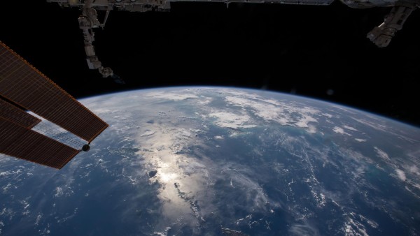
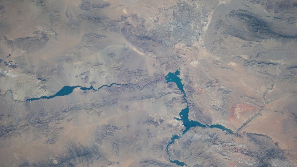
Areas of application
Remote sensing can be used to prevent and avoid crises, but also in the follow-up and reconstruction phase.
You advocate expanding the methodology for mapping. What does this mean in practice and what factors need to be considered?
Martin Voss: I define mapping very broadly. An ideal map for me is one that includes various infrastructures and risk types. The political and societal conditions are integrated in superimposed layers but, for example, so are religious and spiritual relationships. These factors should be understood as a resource. For example, I am familiar with the special case of the Merapi volcano in Indonesia that perhaps illustrates the range of resources relevant to disasters. The mythology there is oriented around coping with the loss of family members as a result of an eruption. The victims are seen as martyrs that were summoned by the volcano. This increases the standing of the family that is mourning a victim. This is only one example of many similar mechanisms that are highly complex but, at the same time, elementary. If a geophysicist who only thinks in terms of technology is sent there, it is perceived by the local people as an offence against their own "institutions". I think factoring in these kinds of cultural aspects is not a trivial matter, but extremely important. Nuances of this kind exist everywhere in the world. Even the most enlightened, rational societies have their everyday practices for dealing with tragedies. A region which, from the natural sciences perspective, appears in dark red on a map – due to high risk – can look totally different up close because the people have developed the capability to adapt over hundreds and thousands of years and have learned to live with their supposedly dangerous environment. If the region is indiscriminately mapped as "red and at risk" and this map is published, investors will pull out in some cases and a vulnerability is potentially created that didn't exist before.
Michael Judex: This is actually an exciting approach. It addresses a problem that I also see. All of this technology – remote sensing but also GIS – originated in the natural sciences, in the environmental sciences. As a result, the map shows what can be seen through the glasses of natural science. But the world is much more complex. There are mechanisms that cannot be quantified, but that can still help stabilise society in countries with high vulnerability. We must not forget this.
Are there risks associated with remote sensing – for example, misuse of information?
Michael Judex: Yes, there are risks. However, the European Commission has developed validation mechanisms for every request received. It is first scrutinised who the enquiry is from. A check is then performed to determine whether the region over which the image is taken has politically sensitive features – and I formulate this abstractly. In this case, a request can definitely be rejected. There was recently a case of this kind in Libya where photos were initially taken for humanitarian assistance. However, it turned out that military operations were taking place there at the same time. Authorisation for the photos was withdrawn as a result and since then the validation criteria have been tightened up accordingly. Can you give us an example of where you have been able to make a particularly useful contribution to the analysis of crises and disasters or to the practical implementation of promising approaches with your expertise?
Martin Voss: The "Global Initiative on Disaster Risk Management" pursues a helpful approach that we support. It asks the question, among others: what structures do we have for disaster management in Germany and in what cultural conditions in other parts of the world do they fit? This process takes into account that we do not have the capability to do things better everywhere. We first have to analyse the local conditions and capacities and determine whether our systems actually help the people there. We consider a national system in detail and prepare it conceptually in such a way that it can be transferred and translated to another culture – if it is sufficiently compatible. It is not applied 1:1, but adapted to the respective context.
Michael Judex: The entire methodology of remote sensing is still relatively young. But we have gradually reached the point where the technology can be applied to everyday problems. We were commissioned by the German Federal Agency for Technical Relief (Technisches Hilfswerk, THW) to create a map of the Zaatari refugee camp in Jordan on the Syrian border. The German Federal Agency for Technical Relief is providing humanitarian assistance there. The maps show how the refugee camp has grown from a relatively informal, unorganised structure into a city with nearly 100,000 residents in just one and a half years. The reason the map was created was a crisis; the camp was at risk of flooding. Using satellite and radar images, it was possible to see which areas were affected and where drainage needed to be built to allow the water to drain off as quickly as possible. The final map is a complex product: a satellite image in the background with the relevant risk analysis, in this case flooding, superimposed over it.
Does this mean you were called ex post?
Michael Judex: Yes. This is the difficulty in emergencies: it takes at least two to three days for the maps created from the satellite images to actually reach the user. The satellite images first have to be taken and then analysed before the result can be sent to the end user. Unfortunately, we still can't do this any faster. We haven't yet reached the point where we have the data a few hours after receiving the request due to system limitations.
Source
This article has been published in the 14th Evaluation Report 2015-2016.
In your opinion, what is the biggest weakness of your discipline?
Michael Judex: “Copernicus” remote sensing and geodata are always only one component of many. The interdisciplinary, the sociological aspects are just as important. And quite simply, they cannot be recorded with a satellite image. You can only quantify events with remote sensing of satellite images, you can capture events on the earth's surface, certain natural phenomena, but aspects related to vulnerability are much more complex. We always have to keep this in mind. We also regularly find that remote sensing products may contain errors. Inaccuracies can emerge in the maps during processing and analysis that can lead to misinterpretations. Even if satellites have high resolution, they only observe from above and not from the side. Nevertheless: when these kinds of maps are on the table, they serve as a good basis for a discussion to present the various perspectives of the participants. This certainly seems to me to be added value even if this was not necessarily the intention of the inventors of the satellites.
Martin Voss: To market our approaches better, we social scientists have to learn to communicate across the boundaries of various disciplines and to give more recognition to the benefits of things that we usually tend to criticise too generally. For example, I view both approaches – disaster sociological research and remote sensing – as entirely complementary. There is one perspective on the ground that is completely different from the aerial perspective. Blending the two is ideal. When the two cooperate with one another, a picture emerges that is more true to life.
Thank you for the interesting discussion.
Published on KfW Stories: Tuesday, 23 May 2017
Data protection principles
If you click on one of the following icons, your data will be sent to the corresponding social network.
Privacy information