Innovation
Managing projects remotely
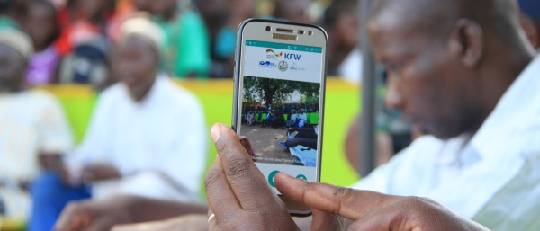
Maintaining the ability to act despite the pandemic, including in fragile contexts – Remote Management, Monitoring and Verification (RMMV) makes it possible to manage projects from a distance. It gives donors a better overview and increases target group participation, but it also carries new risks.
Remote-Management Monitoring and Verification
Video: Mode of action of RMMV (KfW Group/Muthmedia)
The coronavirus pandemic has radically altered daily life in most countries around the world. Since it began, a great deal of patience, flexibility and innovation has been required in every field. Development cooperation is no exception. It had to change practically overnight and adapt its ways of working to suit the new context. On the one hand, possibilities to conduct on-site checks were extremely limited in many countries starting from March. On the other, demand for international assistance increased considerably as a result of the pandemic and all of its consequences. This made it even more urgent that we continue to follow up on and support projects and launch new ones.
Normally, KfW’s project managers travel to their partner countries regularly, talking to stakeholders, preparing new projects and checking whether projects that are underway are progressing as expected. Some aspects can be handled in capital cities or regional centres, especially in connection with financial sector activities or reform financing with the central government. However, one of the key functions of development cooperation is still expansion and renovation of infrastructure. For construction measures like roads, schools, hospitals, grain stores and water pipelines, KfW monitors construction progress directly on site. Even if they are partly reliant on random sampling, these repeated visits to the partner country ensure that projects are running smoothly and achieving the desired impacts. The pandemic disrupted this routine.
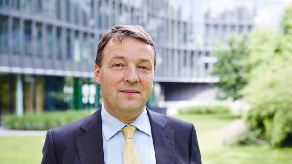
Dr Jochen Harnisch
Head of Division at KfW (Agriculture, Water, Biodiversity for West Africa & Madagascar)
In this situation, KfW can draw on its experience from regions where local checks have not been possible for a long time, even though the reasons are unconnected with coronavirus; this is the case in Afghanistan and Pakistan in particular, and in parts of West Africa, which is the focus of this article.
The Sahel, comprising the countries of Mali, Burkina Faso, Niger and Chad, is a turbulent region, but one that is also strategically important from a European perspective. There, violence and terrorism are combined with poverty and political instability. That is why there are fears in Europe that the fragile situation could spill over into North Africa and the coastal states of East and West Africa. Due to its strategic significance, the German Federal Government is pursuing the aim of bringing peace and stability to the region and creating opportunities for people there. Development cooperation is an important building block in this process.
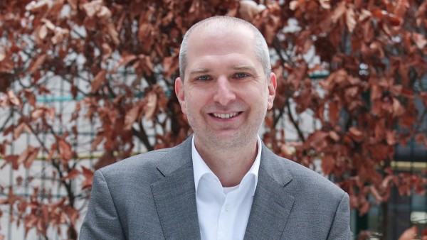
Meinhard Rögner
Technical Expert at the KfW team (Agriculture, Water and Biodiversity for West Africa & Madagascar).
Due to the security situation, however, KfW is increasingly supporting its projects in this region from a distance, the key phrase being “remote management, monitoring and verification”. This involves managing projects, keeping track of them (monitoring) and supervising them (verification) from a distance. Technical tools are available to facilitate this: images taken using satellites, airplanes or drones, georeferenced databases and digital project guidance applications. However, personnel in the country, either locally employed KfW staff or consultants who still have access to the project region, also play an important role. They are, in a sense, the “eyes and ears” on the ground. Usually a combination of the two approaches is required, either with dialogue online or using online image transfer via virtual reality apps.
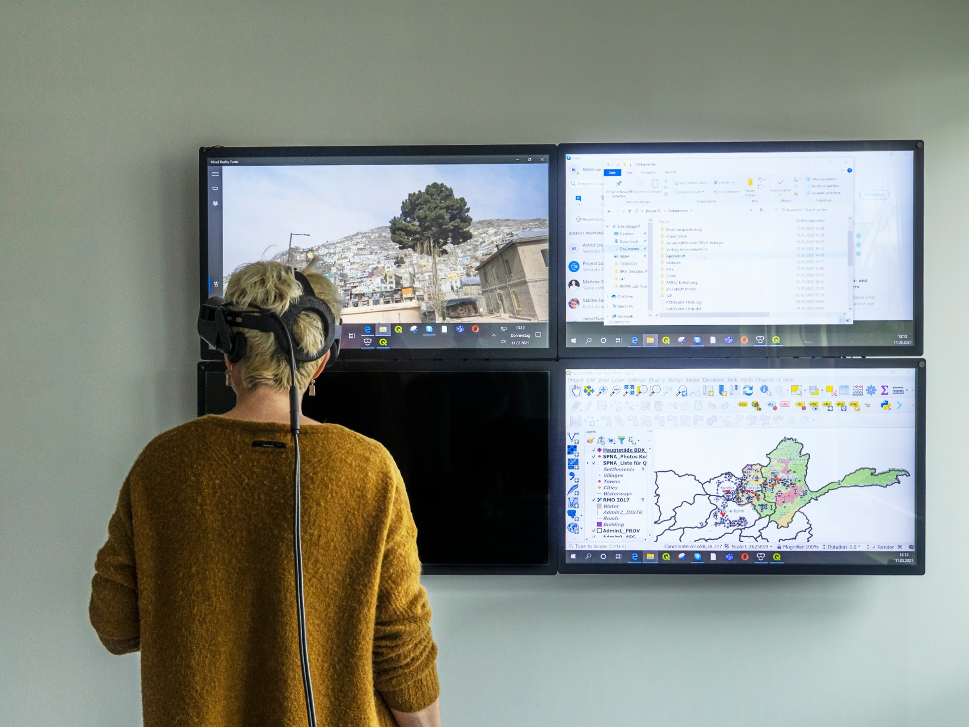
Virtual reality
Projects are controlled, tracked and monitored remotely from Frankfurt. Technical aids such as images taken by satellites, aircraft or drones, geo-referenced databases and digital applications for project control are available for this purpose.
Burkina Faso example: here, development funds are used to support local construction projects in municipalities. These are designed to meet the needs of the local population and boost the local economy. They could be schools or health stations but can also include markets or roads. The building sites can be anywhere in the country and it is difficult to track how construction is progressing. The security situation renders checks trickier still. That is why KfW deploys a remote management information system called KoBoToolbox. It is an open source digital data collection programme into which all information, including photos, flows. Fieldbuzz – a system provided by a private company and therefore not open source – is also used in West Africa. The imagery captured there is georeferenced and labelled with the date and time the photo was taken. It can be assigned to the location on a map of the country. Fraud using photos of other construction sites is not an option.
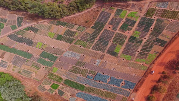
Photographs of fields in Mali
Drones are recommended for smaller areas with a radius of around three square kilometres. They are battery-powered and connected directly to a smartphone of the implementation consultant on site. The visual material can then be processed and sent directly from the mobile phone.
In simplified terms, the end-to-end process currently works as follows: a consultant or a representative of the project-executing agency based locally uses a standard smartphone to take photos of the building site. They write a report on the status of the project, based on set criteria and using the structure pre-defined by KfW, and store both in KoBoToolbox. There, the project coordinator in the country performs an initial review of the material and approves it for release. The responsible KfW staff member can then access and check the information from Frankfurt. He or she views a map of the country and/or the project, clicks on a little flag for each location and calls up the latest information on it. This facilitates precise assessment of whether the building has a roof yet or the new road has got longer since the last appraisal. If there are doubts or further questions, the executing agency will receive instructions on points to be rectified and must evidence that these have been actioned by providing new photos and reports.
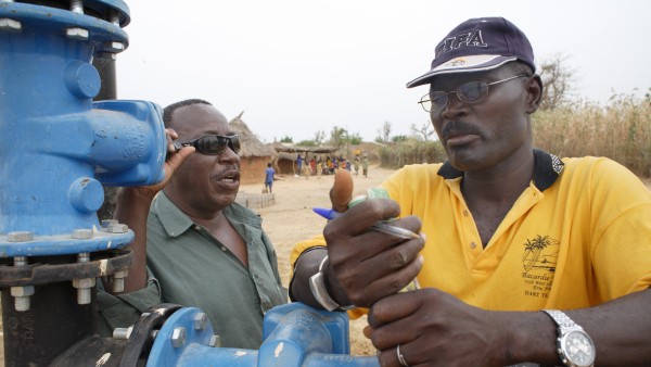
KfW also manages projects remotely in Mali, primarily in the north of the country. It is particularly prone to unrest and violence, but the area along the Niger River is well suited to agriculture. The country could become a source of food for the entire region. Of the estimated 2.2 million hectares of usable land, only about 20 per cent is being farmed. Improved irrigation has the potential to vastly increase the size of this area. Small perimeters (defined areas), dams, pumps, canals, wells and erosion control measures could have a major impact. In order to exploit this potential despite the difficult circumstances, KfW uses digital tools to support its irrigation programmes there remotely.
Water fountain in Mali
KfW manages projects from Frankfurt, particularly in the north of Mali. Along the Niger River, this region is well suited for agriculture. Small perimeters (demarcated areas), dams, pumps, canals, fountains and erosion control measures can help the country develop into the "food chamber" of the entire region.
Drones are ideal for smaller areas with a radius of around three square kilometres. They are battery operated and directly connected to the smartphone of the local implementation consultant. The phone can then be used to process and forward the imagery. It is precise enough that larger buildings and dam walls are easily recognisable, especially any changes since the last photo. Satellite images are also used. They are well suited to larger areas and can answer questions like: Has there been an increase in the total size of the area being farmed? Have there been any erosion events? Have canals been built and perimeters established? They can even help to clearly distinguish between different types of crop, such as maize, rice, lettuce, cabbage and onions. However, the cost is usually higher than for drones because the imagery must be purchased. This is why KfW tends to use this technology for targeted comparison at less regular intervals and in fixed cycles.
In West Africa, there are already 50 projects using remote monitoring techniques. Experience to date shows that these are a good substitute for in-person checks that would otherwise not happen in times of crisis, but they have their limitations: there is a lack of contact with the target group and the executing agencies. During progress reviews, it would usually be possible to speak with beneficiaries too, asking parents whether they are really satisfied with the new school, going to the local farmers to check whether the well is actually working. In short: one can gather views from a range of perspectives, unfiltered and in addition to the official data. This opportunity is lost. Despite high-resolution imagery, perception is limited: it is only possible to see an extract; one can’t hear, taste or smell anything. Information remains two-dimensional; when they only work digitally, the responsible KfW staff cannot see whether the strut was actually anchored 1.5 metres into the ground as required.
The second lesson: in order to be effective in the longer term, these solutions must be adapted to suit the situation and local systems, and this comes at a cost. Partners in these countries must be brought on board, trained and familiarised with the processes, not to mention our own learning needs. This shows that in many cases, remote monitoring saves neither time nor money. Those who only see the reduction in travel and the associated costs are sadly mistaken. The expenditure will just crop up somewhere else. However, once such systems are established, they can make work noticeably easier and, above all, allow infrastructure projects to be carried out in areas where development cooperation would not be possible otherwise.
And thirdly, we have seen that remote monitoring can also offer benefits in “normal” times, namely in cases where a programme is fragmented and its individual sites are spread across a large area. For example, it is relatively straightforward and efficient to monitor construction of a hospital by visiting it when visits are an option. When several small infrastructure projects are spread across a whole area or even an entire country, that becomes more difficult. Where we previously had to rely on random sampling, it may now be possible to conduct even more comprehensive monitoring using these solutions. Digital tools are also a huge improvement over previous solutions when it comes to recording and monitoring larger areas, such as agricultural land, a conservation area or a band of forest. The same applies to ex post evaluation of projects once they have ended, which is a standard element of development cooperation.
Managing projects remotely with all of these new technical capabilities can provide a state-of-the-art boost to the standard range of instruments. In regions beset by crises, it offers ways to continue with construction work. And in areas with no travel restrictions, it can help to improve the quality of projects and monitor impacts quickly and more comprehensively. In any case, KfW’s experiences in West Africa and in other regions show that infrastructure projects remain feasible even in difficult conditions and that they can help to stabilise and rebuild areas impacted by crises in this way.
Published on KfW Stories on 3 August 2021, updated on 2 August 2023.
The described project contributes to the following United Nationsʼ Sustainable Development Goals
Goal 9: Build resilient infrastructure, promote sustainable industrialization and foster innovation
Non-existent or dilapidated infrastructure hinders economic efficiency and thus engenders poverty. When building infrastructure, the focus should be on sustainability, for example, by promoting environmentally-friendly means of transport. Factories and industrial facilities should also ensure that production is in line with ecological aspects to avoid unnecessary environmental pollution.
All United Nations member states adopted the 2030 Agenda in 2015. At its heart is a list of 17 goals for sustainable development, known as the Sustainable Development Goals (SDGs). Our world should become a place where people are able to live in peace with each other in ways that are ecologically compatible, socially just, and economically effective.

Data protection principles
If you click on one of the following icons, your data will be sent to the corresponding social network.
Privacy information